Tuesday 30 July 2013

Kimberley Tour - 28 July


Broome:  28 July

The final day of our tremendous tour 
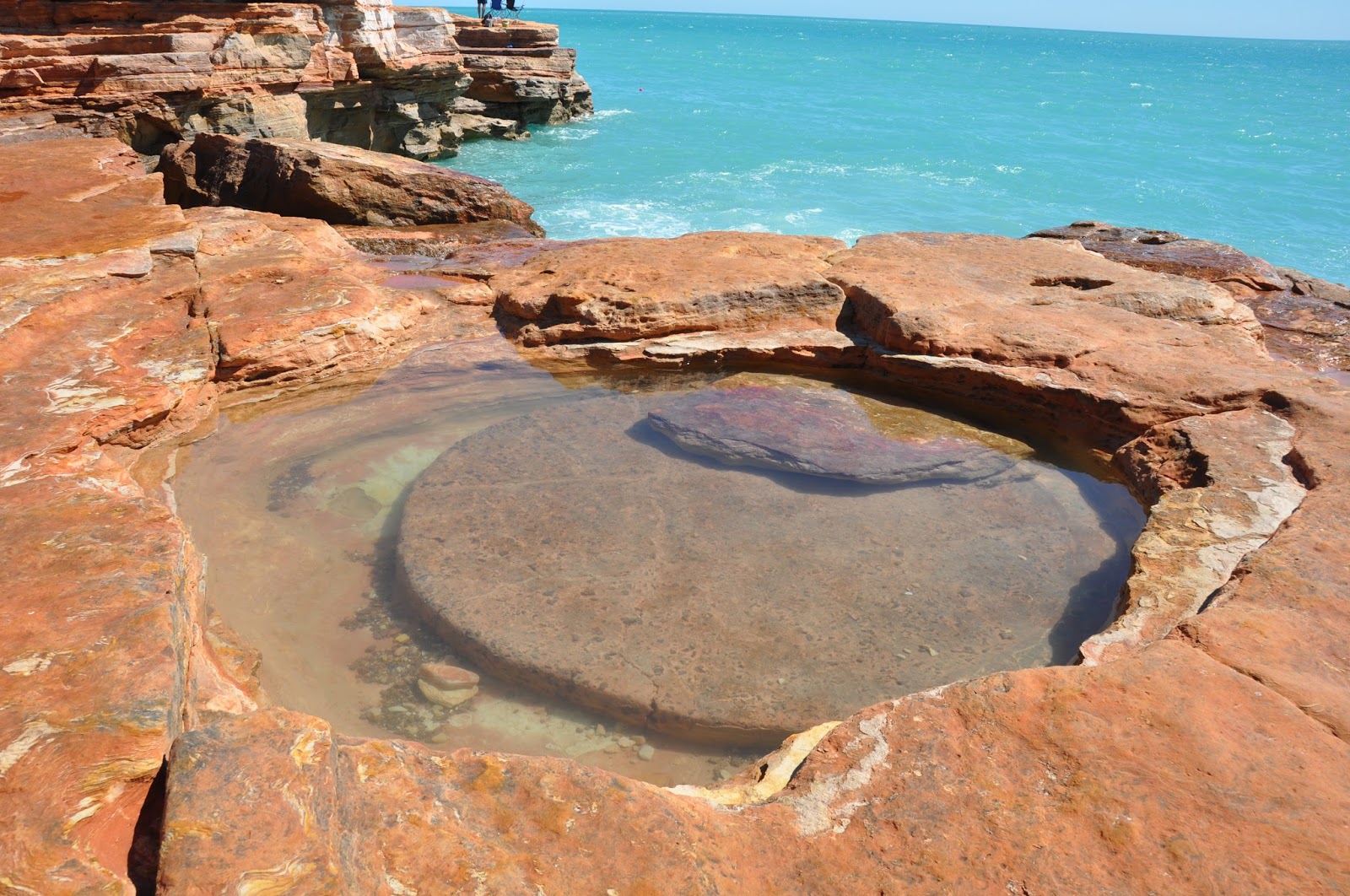
of the Kimberleys was a sightseeing trip around Broome, including Gantheaume Point with Anastasia’s Pool and the mock-up of the dinosaur footprints, Chinatown, the Japanese cemetery and the Pearl Luggers Museum.  Guess who got to hold one of the biggest pearls ever?

Our driver for this trip was Andrew and he was extremely knowledgeable about the history and current situation of Broome.  We saw the models of the dinasour footprints (the real ones were under 8 metres of sea water) and Anastasia's pool.


After lunch we all relaxed.  Some of us caught a wave or two at Cable Beach while others enjoyed the pools at the resort.  Later in the day, we watched the sun set along with a large number of other people.  It is evident that Cable Beach sunsets are quite an institution!


The final activity of our tour was our farewell dinner – where we thanked Paul for his magnificent efforts in taking us for 3,600 km through the Kimberleys on such an unforgettable journey. 

As we reflect on our tour, we realise that we have been on quite an adventure through some of the most remote and difficult to access country in Australia - the Kimberleys in north-west Western Australia.

Kimberley Reflection

As travelling to the Kimberleys was such a long standing ambition and spending time in the Kimberleys was such an integral part of our trip, it is worthwhile making some brief reflections on what our trip through the Kimberleys has involved and what it has meant to us.

 The first aspect that became apparent is that there is not one Kimberley but various ‘Kimberleys’ – there is east Kimberley, there is west Kimberley and there is central Kimberley.  Each of these regions has its own identity and its own character, although there are clearly overlaps in a number of respects.  There is the Shire of Derby West Kimberley, the Shire of Wyndham East Kimberley and, in the more central area, the Shire of Halls Creek.  Of course, one of the main factors is the sheer size of this region and the need to break it up into more manageable administrative areas.

 The vastness of the Kimberleys can only be properly realised by moving around the region.  The road distance from Broome to Kununurra, for example, is 1,067 km.  While this is a good quality sealed road, the locals still don’t refer to travel in terms of distance but in terms of time:  for example, it takes 11 hours to drive this journey.  This approach is appropriate when considering the many unsealed roads:  the 60 km along the extremely rough Port Warrender track take 2 hours and the 50 km into the Bungle Bungles take nearly 2 hours.  When we flew from Broome to the Horizontal Falls in Talbot Bay, it took over an hour – and that only covered a small part of the west Kimberley! 

 It was not until we set off along the Gibb River Road that the extent of the flat savannah and grazing country became apparent.  Rather than the rugged country with mountains and gorges we might have been expecting, much of the Kimberleys is flat or undulating.  Moreover, there are various plateaus – such as the Mitchell Plateau and the Gardner Plateau and travel across the country can involve negotiating ‘jump ups’:  that is, jumping up from one level to the next, often involving quite steep climbs.  Of course, if you ‘jump up’, you inevitably have to ‘jump down’ as well.
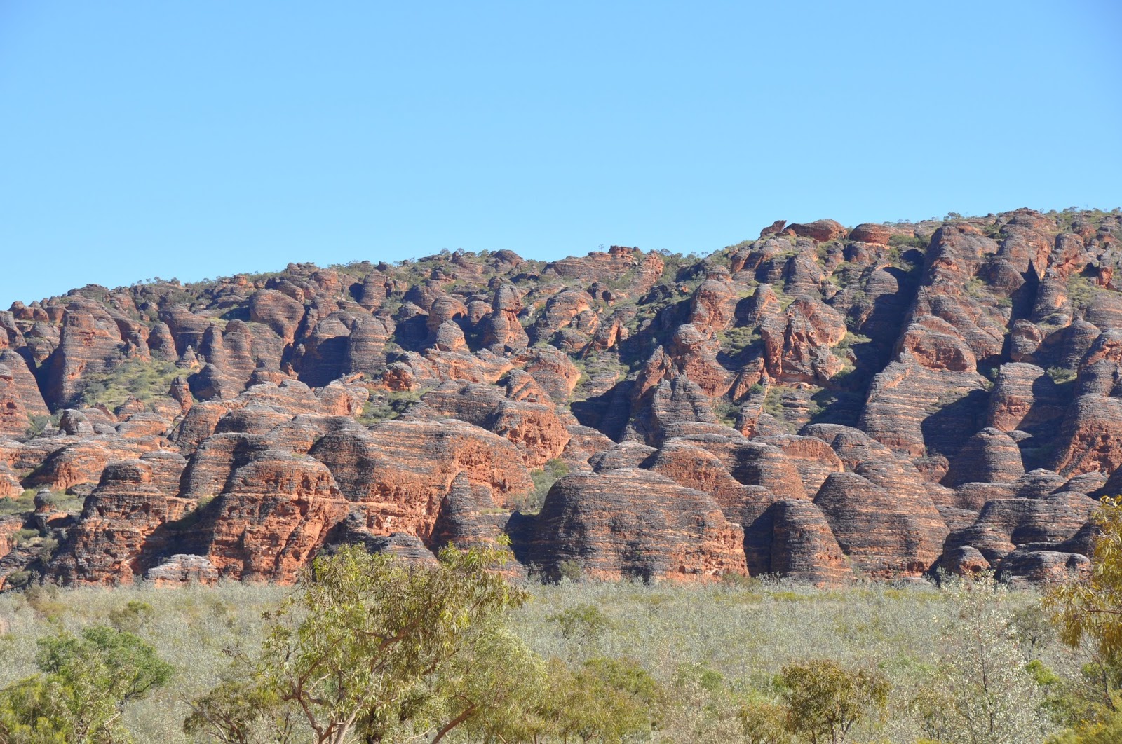
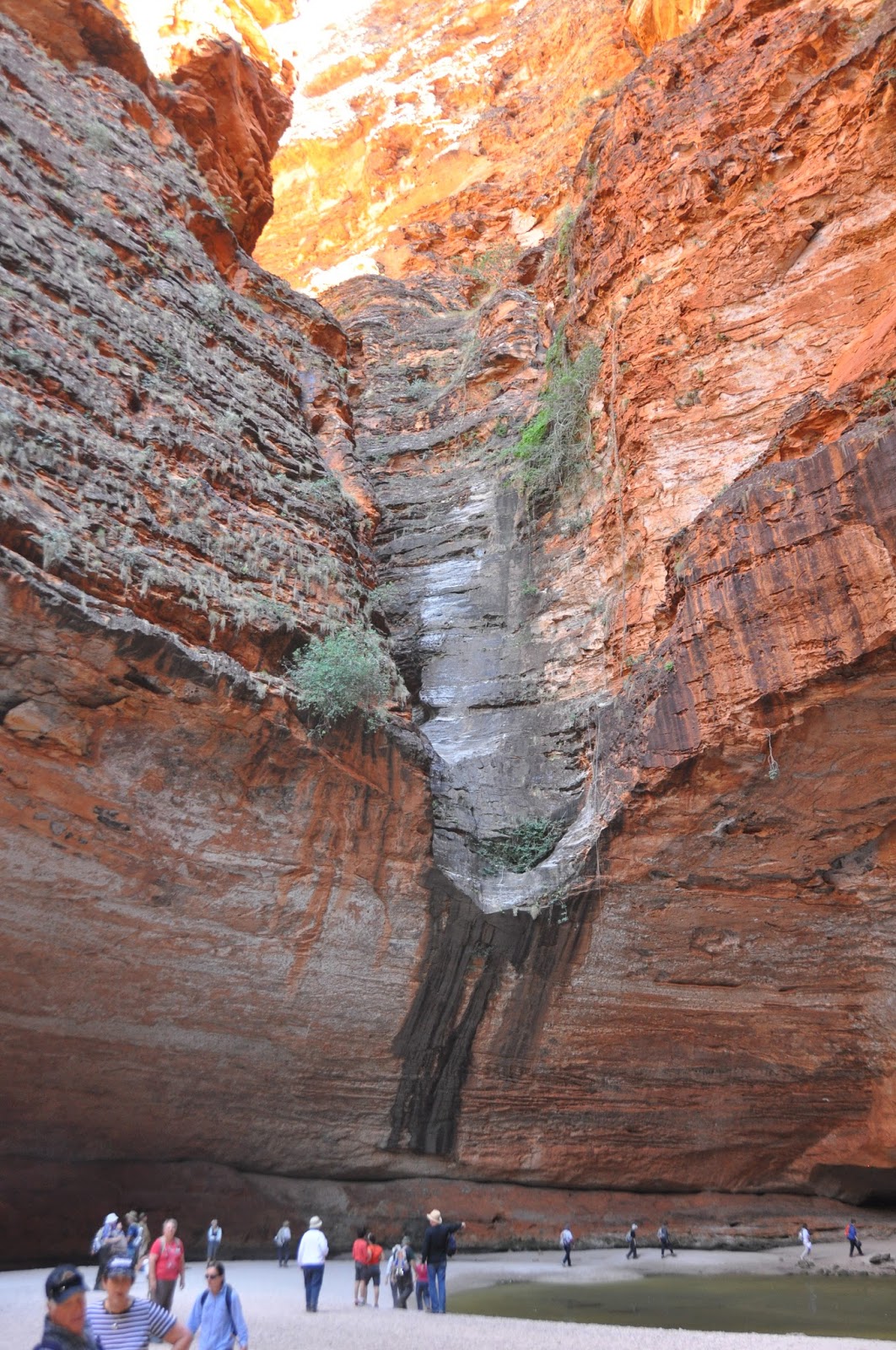
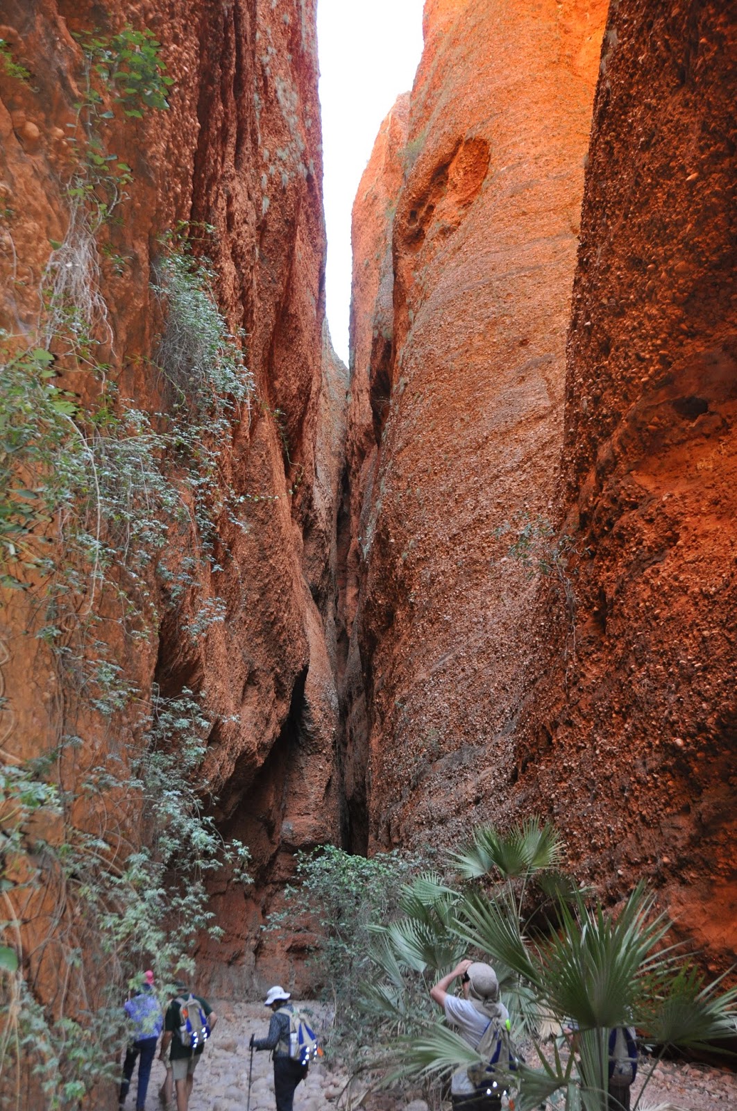
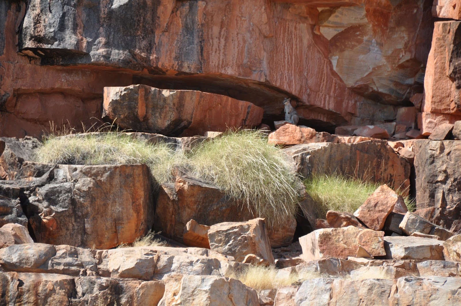
 The geology and geography of the Kimberleys are quite fascinating.  The rocks of the region are some of the oldest on earth and the various landforms are amazing as is the way in which erosion and other forces have shaped the landscape.  The consequences of these actions now see many fabulous rivers, gorges, waterfalls and permanent waterholes scattered across the Kimberleys.  The flora is equally interesting, with the extra-ordinary boabs, the kapok bush with its bright yellow flowers, the unique livistonia palms on Mitchell Plateau and the elusive Kimberley rose being a small selection of many plants that are seen across the Kimberleys.

Given all the characteristics of the Kimberleys, it is not surprising that many parts are quite remote.  Some, such as Cape Leveque, the Mitchell Plateau and Kalumburu can be accessed by road – albeit by using at times unformed and irregularly-maintained roads which are very slow and require extremely careful negotiation according to the conditions.  Some parts are only accessible by air or by ship – and, in the wet season, access may be even more restricted with road closures and inclement weather.

 Associated with the issue of remoteness is the question of the quality of some of the roads.  One of the beautiful features of the Kimberleys is the fact that to use road transport requires 4WD in many instances.  In some parts, however, such as at the north-eastern end of the Gibb River Road, work is in progress to upgrade this section of road to enhance access to such areas as El Questro and Emma Gorge. 

This creates a dilemma:  should the roads remain as gravel roads or should they be upgraded?  There are various issues with retaining roads essentially as they are at present, with the many low level crossings of water courses, the road closures in the wet season, some very rough sections and the cost of maintenance – all of which mean that only people who have made the proper preparations can travel through the Kimberleys by road.  Alternatively, should at least some roads be upgraded and even sealed to increase access for more people? 

 In our view, part of the inherent beauty of the Kimberleys is the natural ruggedness of the region.  It is this ruggedness, combined with being so remote, that makes the Kimberleys such a desirable region to visit – and it is these characteristics which should guide how this region is to be managed.  In our view, the principle should not be one of there being ease of access.  Rather, the guiding principle should be that, if people want to visit the Kimberleys, they must make appropriate preparations to do so.  Upgrading and sealing roads will diminish the essential character of the Kimberleys.  Nevertheless, we can see increasing pressure being applied to upgrade roads.  The key question is to achieve the appropriate balance in responding to these pressures.  Of course, there will be times when, despite the best efforts of humans, a good wet season may create havoc on infrastructure throughout the Kimberleys – and there will be little we can do about that!

 If possible, everyone should attempt to visit the Kimberleys.  The variety of the region is astounding, the beauty of the region is magnificent and the influence of indigenous peoples throughout the region is fascinating – reaching back over thousands of years.  It is well worth seeking an understanding of all that the Kimberleys have to offer.  It also will be interesting to see how the Kimberley region continues to develop – with the expansion, for example, of the irrigated area around Kununurra and the development of new mining projects. 


Kimberley Tour - 27 July


Fitzroy Crossing – Broome:  27 July [501 km]

We had another early start with a long day ahead:  our first stop was Tunnel Creek National Park.  Most of us set off to scramble down into the tunnel and then walk the 750 metres through the tunnel;  this walk involved some splashing through the cool water of Tunnel Creek. 

There is a beautiful silver "curtain" which has been created inside the tunnel through the action of water dripping through the limestone.

The tunnel has been eroded right through the Oscar Range and, where the creek leaves the Range, there is a lovely sequence of water holes for swimming and cooling off.


Then it was off to Windjana Gorge along a road that has a number of patches of black soil.  This road quite rough and would be impassable after any fall of rain.  Windjana Gorge is awe-inspiring, with its towering cliffs.  In places, the walls of the Gorge stand up to 100 metres above the floodplain.  
 
There are permanent pools of fresh water and these are home to a large number of fresh water crocodiles.  They were enjoying the sun for most of the time although they would dash into the water if they felt threatened.  We enjoyed seeing these crocodiles in their natural environment and we even made some new friends!


After lunch, we drove on to Broome, where we arrived in late afternoon and booked in to the luxurious Cable Beach Club Resort.

Kimberley Tour - 26 July


Bungle Bungles – Fitzroy Crossing:  26 July [475 km]

This was another early morning departure as we had a long distance to cover.  We drove out of the Purnululu National Park along the notorious track and turned south to Halls Creek.  We had lunch at a lovely spot where the highway crosses the Mary River and then we continued till we reached Fitzroy Crossing.

After booking into our motel, we travelled out to Geikie Gorge National Park for a cruise on the mighty Fitzroy River.  The River has carved its way through an ancient limestone barrier reef, exposing age old fossils on the walls of the gorge.  Geikie Gorge is simply stunning:  high sheer cliffs and amazing erosion of the lower rocks by the force of the wet season water flows with the sand contained in the water.


As we were doing this cruise so late in the day, we also were treated to spectacular colours from the setting sun on the towering walls of the Gorge. 


Our time in Geikie Gorge was extremely rewarding – especially when we stopped the motors and listened in silence to the bird calls and other sounds.  It was a quite a spiritual experience.

We returned to Fitzroy River Lodge to enjoy dinner and to celebrate Marianne becoming a grandmother.

Kimberley Tour - 25 July


Bungle Bungles (Purnululu National Park):  25 July [92 km]

We were up early to get to the heliport for our flight over the Bungle Bungles. 

In cool but crystal clear conditions, we enjoyed a truly remarkable flight over the Bungle Bungles.  Again, our helicopter did not have any doors - but, as we were not flying tight figures of eight (as we were over the Mitchell Falls), we felt far more secure as we flew over the range.

Our pilot, Glen was a fount of knowledge and his insight into the range and the influences which had formed it was exceptional.  At last, we were able to appreciate the structure of the Bungle Bungles:  the ‘beehives’ are on the south east corner of the range and there are tremendous gorges cut right into the range.  The most notable of these is Piccaninny Gorge, with its five ‘subsidiary’ gorges or fingers reaching even further into the range. 

Our flight ended as we spent a few minutes circling over the striped beehives – the orange and black beehive-shaped domes – and seeing how some are layered within the range itself, while others have become separated from the major part of the range. 


This flight was excellent and essential to gain a proper appreciation of the structure of the Bungle Bungles.  It was an exhilarating start to our day in Purnululu.

We drove into the south east part of the Bungle Bungles to Piccaninny Creek.  There, we walked on a reasonably easy track along the creek watercourse (it was dry) and then turned off into Cathedral Gorge.  As we walked in, it was possible to appreciate from a different perspective, the size of the domes and the cliffs.  Some of the cliffs were 300 metres high and they were vertical and sheer. 

There is a fault line running right through this gorge and it can emphasise the brilliant colours of the rocks.

 
This is a superb example of a fault line running through the most remarkable amphitheatre at the end of Cathedral Gorge:  an extremely large area with overhanging rock which provides excellent acoustics. 
 
The entire effect was overwhelming:  the high cliffs;  the colours of the fragile sandstone rocks;  the narrow gaps between the Gorge walls.  What an extra-ordinary place!

We dragged ourselves away to return to our camp for lunch.  After lunch, a number of us drove to Echidna Chasm (so named because of Aboriginal stories) in the north of the park.  While this walk was far more demanding, the effect of the Chasm was even more pronounced.  Here, the walls narrowed in to the extent that at some times it was just possible to walk without touching either side of the cliffs.  


High above, there were overhangs of rock (and some pieces had fallen over the years and were snagged in the narrow gaps:  we assumed they would not fall any further!) and plants, including palm trees, growing everywhere. 

 
This walk provided a different perspective on the Bungle Bungles, as the rock was sedimentary and much more resilient than the sandstone of the domes in the south east.  As we walked out, the sun produced a blazing effect on some of the cliff faces:  again, this was an absolutely amazing sight.

Purnululu National Park:  Wow!  This place is an absolute ‘must’ for people to visit.

Kimberley Tour - 24 July


Kununurra – Bungle Bungles:  24 July [362 km]

In bright sunshine, we drove to Ivanhoe Crossing (watching out for estuarine crocodiles) - this was the original crossing of the Ord River for the road into Kununurra and around the irrigation area at Kununurra before stopping at the sandalwood factory. 

It was good to get an insight into the history of agriculture in this region and to learn what crops are being grown successfully now after many years of trial and error in the Ord River Irrigation Scheme.

Then we set off back down the Great Northern Highway on our way to Purnululu National Park.  After a couple of hours of bitumen road, it was quite a shock to turn onto the road into the Bungle Bungles.  Even though we were aware of the nature of this ‘road’, it was still startling to experience the continual hills, tight bends and (mostly dry) water course crossings:  it took two hours to travel 50 km!

Our first view of the Bungle Bungles was surprising because there was no sign of the famous ‘beehives’.  Nevertheless, the range quite stunning in the late afternoon sun. 

The Bellburn Safari Lodge was a very welcome sight after a long and bumpy journey.  We were welcomed by Fran – who ran the site and who also cooked our meals.  She is a real dynamo and made us feel very relaxed.  As we were now a fair way inland, as the sun set, the temperature fell quite quickly.  The Lodge camp fire provided warmth as the evening cooled down.

Kimberley Tour - 23 July


El Questro – Kununurra:  23 July [263 km]

We know this sounds boring but, on another absolutely stunning day, we set off for Wyndham for a visit to 5 Rivers Lookout.  This was another feature which we had been anticipating.  The lookout is located on a quite high hill and provides spectacular views of Wyndham and Cambridge Gulf.  Across the extensive mangrove-covered tidal flats, we could see where the Ord, King, Pentecost, Durack and Forrest Rivers enter Cambridge Gulf.  In the distance to the south west, was the towering Cockburn Range, so the whole effect of the view from this lookout was absolutely captivating. 


It was a splendid place at which to enjoy morning tea and wonder again at the beauty of this part of Australia.

One fascinating development at this time was that we were driving over bridges again;  for about a week, we had seen very few bridges and we had driven through numerous water courses, some of which had water in them.

Then we set off to Kununurra (where there was some furious shopping for diamonds and such like!) before we drove out to Lake Argyle, visiting the Durack Homestead Museum along the way. 

Lake Argyle looked magnificent as it stretched away into the far distance:  what an enormous volume of water and it looked so blue on such a clear day.  

We had lunch below the dam wall in a delightful picnic area.

Our trip down the Ord River beckoned, so we boarded our boat with Dillon – a very knowledgeable local lad – for an exhilarating 3-hour cruise down the Ord River.  Dillon knew just about everything there was to know about Lake Argyle, the dam, the hydro power station, how Lake Kununurra and Lake Argyle have influenced the economy of the region and the environment and flora and fauna of the Ord River below the dam. 

Some of the locals were fishing (by almost walking on water)

...while others were content to sleep with their mouths open...

We had a wonderful time with Dillon alternatively stopping to point out matters of interest and using his two V8 outboard motors to speed us down the River.  A couple of rock wallabies took some interest in us...

...while the local bats could not care less...

Near the end of our river trip, we saw a sleeping elephant

This was a fascinating time as we learnt about this area and we completed this trip with sunset over Lake Kununurra.  We enjoyed a relaxing dinner and evening at the Kununurra Country Club Hotel.  We also managed to get some reception for our mobile phones after a week of not being in communication with the outside world.

Kimberley Tour - 22 July


El Questro Wilderness Park:  22 July [80 km]

The Emma Gorge resort is located right under the Cockburn Range - and the golden morning sun was simply brilliant.

We set off on another beautiful day for El Questro ‘township’ – which is predominantly a large caravan park and camping ground on the picturesque Pentecost River.  Then we drove the short distance to the Chamberlain Gorge.  Jim and Olley were waiting for us to board their boat for our cruise along the 3km fresh waterhole.  The cruise passes through towering escarpments which have been eroded by the Chamberlain River over what is thought to be millions of years.  

Indeed, the Chamberlain River could be the oldest river in the world.  We did see a rock wallaby and one freshwater crocodile as we travelled along the waterhole.

At the top of the waterhole, after negotiating some very shallow spots, we stopped at a small beach.  As we looked into the water, we were startled to find that we were being spat at by a number of archer fish:  they stay near the surface and, if they see anything shiny, they spit water at it thinking it is an insect. 

We marvelled at these fish for some time, while we fed other fish, including catfish and barramundi.  Jim provided an excellent insight into the history of the magnificent Chamberlain Gorge and even gave us some genuine Australian bush poetry!

We visited the magical Zebedee Thermal Springs on our way out, where some people sat in the crystal clear 30 degree water.  These Springs are located in a patch of luxuriant rain forest and it is a very tranquil spot.

Some of us intended to walk into the Emma Gorge waterfall in the afternoon but smoke from extensive burning off caused the Gorge to be closed.  So, it was into the swimming pool at the resort to cool off and refresh – as we watched numerous birds fly around the lovely eucalypts and other trees.  The setting of this resort right in amongst the Cockburn Range is superb.