Saturday 24 August 2013

Canberra


Canberra:  23 August [781 km]

Well;  we have finally arrived at the final day of our great adventure.  This was to be the longest driving day of our trip but much of this driving would be on familiar roads.

On a very windy day, we said goodbye to Rick and Janene (and Milo) and set off for Uralla.  The statue of Captain Thunderbolt is prominent in the main street of Uralla – on the corner of the New England Highway and Thunderbolt’s Way.

As the wind blew across the high plains, we drove through Walcha and then through the spectacular mountain 
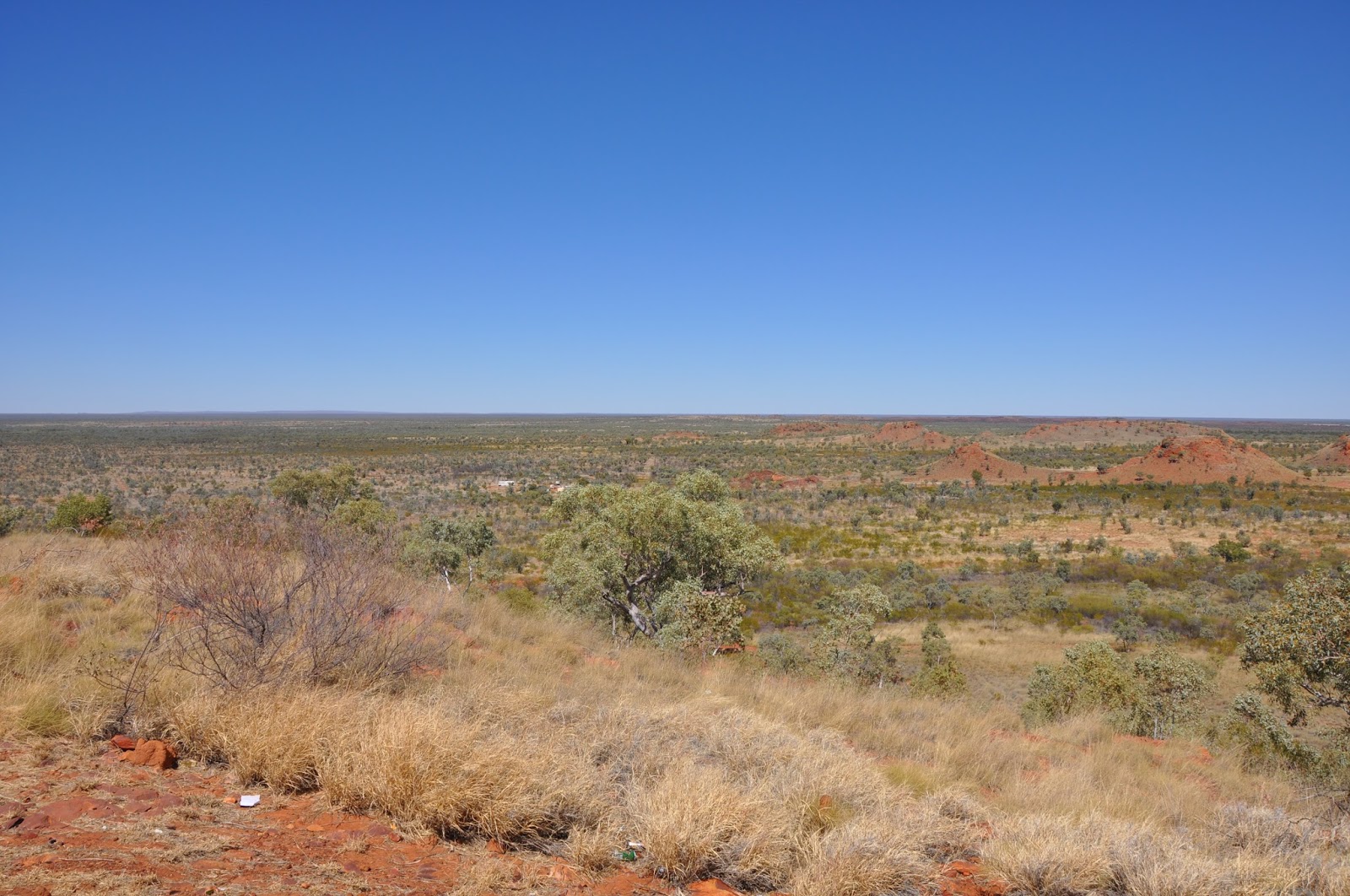
country along the edge of the Great Dividing Range.  Some of the views from this road are amazing, such as this view to the south across a multitude of mountains and valleys.  It is an extremely rugged but beautiful area.

Travelling south, the road falls quite dramatically to the valley of the Manning River (the river, which comes out at Taree, is very small at this point).  We pressed on to Gloucester where we were sheltered from the strong wind and we enjoyed morning tea in the warm sunshine.  Then we continued to the Pacific Highway – a road that is very familiar to us. 

Once we had reached this point, we knew that we simply had to press on to Canberra – and that is what we did, with the strong wind as our constant companion.  Our journey on the M7 through Sydney was smooth and we soon arrived at Sutton Forrest.  As we left after afternoon tea, we drove into low cloud and rain near Goulburn.  We hadn’t seen rain since leaving Perth all those weeks ago!

We arrived home in Isabella Plains at 6.30 pm and gave Tinkerbell a warm welcome.  She seemed pleased to see us but she appeared to have become more frail while we had been away.  We also think that Chanticleer was relieved to be home after travelling more than 15,000 in 11 weeks.  He deserved a bit of a rest too!
 
 
Brief summary
After nearly 11 weeks on the road and more than 15,000 kilometres (or 18,600 by including our tour around the Kimberleys), we had driven a substantial way around the Australian mainland and had experienced a wide range of fabulous activities.  We had seen an enormous variety of landforms, of vegetation, of coastal scenery, of animals both on land and in the sea and we had met a large number people – old friends and new friends amongst others. 

At this early stage, we have packed so much into 11 weeks that it is difficult to think through in detail all that we have done.  There is no doubt, however, that we have had an extra-ordinary adventure – and this has been an adventure that has achieved some notable ambitions, particularly for Tim.  The tour of the Kimberleys, especially the visit to Mitchell Falls and to the Bungle Bungles, and walking in Carnarvon Gorge were two particular ambitions.  For both of us, swimming with the whale sharks was an absolutely unbelievable experience, as was snorkelling on Ningaloo Reef;  the tour to the Horizontal Falls was exhilarating in the extreme (wow!);  Katherine Gorge, Edith Falls and Bitter Springs were superb spots. 
At the same time, we have travelled an enormous distance.  This has meant that, at times, we have covered long distances in a day and travelled through eucalypt forests, flat, flat plains, scrub and savannah.  We have seen, again in some instances, what a wonderful country Australia is.  Its size;  its diversity;  its amazing animals, birds and sea life;  its people. 

In some ways, reflecting on all that we have done and achieved will take a bit of time.  Writing this diary of our trip has been an important part of our trip.  We trust that our experiences might encourage you to consider having a look – or another look – at what our great country has to offer.
It is always good to be in your own home – but what a fabulous time we have had looking at our country.  Of course, we are already planning further journeys: some to places to which we would like to return and others to new places. 

Go for it!

Armidale


Lightning Ridge – Armidale:  21 August [548 Km]

Wow!  We just had a night when the temperature got down to minus 1 – that was a bit of a shock after the weather we have had for the past two months.  Still, we coped with jumpers and so forth.  We got away just after 8.00 am on what would be a quite long day to Armidale.

We drove down the Great Inland Way past Stanley, the enormous emu, and then turned onto the Gwydir Highway:  again, we were driving along new roads for us.  As we turned, we passed a paddock with dozens of emus roaming around;  what an incredible sight after all our travels to finally come across a lot of emus.

Our first stop was Collarenebri for petrol:  it’s only a small town and we pressed on to Moree, where we had morning tea.  We continued along the Gwydir Highway to Inverell, where we had lunch in a lovely park by the river.

Then we turned onto Thunderbolt’s Way and drove through to Armidale along a good quality road which had little traffic on it.  We arrived at the Lewer’s home in Armidale just after 3.00 pm, so that wasn’t too bad after travelling more than 500 km.  [Question:  Who was Thunderbolt and what did he do?]

It was great to see Janene (and Milo again) again and we enjoyed some afternoon tea catching up on news.  Tim then went to the Cathedral to meet Ron and Robyn Perry, who were very busy getting papers organised for the Armidale Diocese’s Synod and other meetings, and Douglas Bucknell – the CEO of the Canberra and Goulburn Diocese’s Anglican Investment and Development Fund.  Douglas and Tim were going to talk with Armidale Diocese about the future of their development fund next day.  That evening, we enjoyed a most relaxing dinner at Rick and Janene’s home, with Ron and Robyn and Douglas.

Armidale:  22 August

After a very relaxed early morning, Tim and Rick set off for the Cathedral to meet with Ron and Douglas to discuss the prospects for the Armidale Diocese’s development fund.  Meanwhile, Janene, Robyn and Kerryn did their own wandering, with a coffee and cake stop for good measure.

After Tim had taken Douglas to the airport, Rick and Janene drove Tim and Kerryn to a lovely river nearby where we enjoyed afternoon tea.  We also tried a bit of platypus spotting without any success.  Rick then gave us a guided tour of Armidale and its environs.  He is a great advocate for his new city and, in part, that is because there seem to be some good fishing spots around. 

That evening, we had a wonderfully relaxed dinner at Ron and Robyn’s home.  It had been beaut to catch up with our friends and spend some time with them.  We relished the opportunity to exchange news on a wide range of topics and generally enjoy each other’s company.

Monday 19 August 2013

Lightning Ridge


Roma – Lightning Ridge:  19 July [432 Km]

We were on the Great Inland Way reasonably early and passed through Surat on our way to St George.  St George is on the Ballonne River and looks a very prosperous community;  we enjoyed morning tea in a beaut little cafĂ©.  As we continued south, we saw increasing numbers of emus:  at last we had found where all the emus were!  There were emus everywhere as we drove to Hebel on the border with NSW. 

Now here is a real gem of a discovery:  the Hebel Store, which is a general store, restaurant and caravan park all rolled in together.  There’s not much at Hebel, apart from the Hebel Hotel and the Hebel Store but Barb and Ralph at the Hebel Store provide refreshments of the highest quality.  Our lunch was simply delicious:  home cooked with lots of fresh salad and Barb and Ralph are delightful hosts.  If you are travelling along the Great Inland Way and need a break, a stop at the Hebel Store.  You will be well rewarded!

We then drove the remaining few kilometres to Lightning Ridge and called in to the Visitor Centre.  Having learnt about “Stanley”, we immediately drove back to the highway and a few kilometres south – where we found Stanley.  Stanley is a Big Emu:  in fact, he is 18 metres tall and he towers over the Castlereagh Highway.  He has been constructed from scrap metal, Volkswagen car bodies and satellite dishes and he makes quite an impression beside the highway!

Later in the afternoon, we walked to the artesian bore baths in Lightning Ridge.  There are two pools at these baths and the water temperature is a constant 39 degrees;  we joined a number of other people who were relaxing in the very warm water. 

What a lovely way to end our day on the road.  After dinner at the bowling club, we had an early night.

Lightning Ridge:  20 August

What has happened?  We woke to a bright and sunny day – but the wind was from the south and it was quite bitter.  For the first time in many weeks, we both wore jumpers!  This is all a bit of a shock after weeks of beautiful sunny and warm weather.
Still, the birds were well and truly up and singing.  We were delighted to have a tree full of Yellow ringed parrots right outside our cabin.


Anyway, we set off to check out a bit more of Lightning Ridge.  Our first activity was to visit the Chambers of the Black Hand.  This is a fascinating combination of an extensive opal mine, an extra-ordinary range of sandstone carvings in underground passages and an underground opal shop.  We had to put on hard hats and climb down more than 100 steps along a narrow passage into the mine workings.  


We spent quite a while walking around the many carvings of famous people, jungle animals, the Last Supper, a Buddha, dinosaurs, super heroes, Egyptian chambers and even Michelangelo’s David. 


The bloke who has done all the carvings is still adding to the collection:  he was carving Jim Carey this morning!  A former opal miner then took us further underground to look at the approach to opal mining in the Lightning Ridge opal field.  It was most interesting to see the changes that have taken place even with opal mining over the past 100 years or so.

Later in the afternoon, we visited the Rector of Lightning Ridge Anglican Church, David Piper, his wife, Joanne and their two sons, Daniel and Luke.  It was great to spend a bit of time with them and exchange stories about our experiences.  We also wanted to encourage them in their ministry here, as it is reasonably remote – although they are enjoying their time here.  As is the case with other similar locations, the Lightning Ridge church gets a number of visitors from grey nomads at this time of year.
We had a beaut dinner at Bruno’s Italian restaurant and then prepared our gear for our run through to Armidale tomorrow.
Oh!  We also prepared for the temperature to drop to minus 1 tonight!  How will we cope?


Sunday 18 August 2013

Roma


Carnarvon Gorge – Roma:  18 July [247 km]

After the strange start to yesterday, today was fine and sunny.  It was great to be woken by the continual laughing of many kookaburras in the trees around the resort.  After they had finished, a myriad of other birds started their calls:  it was beautiful to listen to all these different calls.  Tim walked to the top of a lookout near the Resort to look at the escarpments and cliffs of Carnarvon Gorge in the morning sun.  Then we packed Chaunticleer and set off:  we said goodbye to some of the locals (of which there were lots around the Resort) and, after travelling more than 12,000 from Canberra, we finally saw some emus as we back tracked to the Carnarvon Highway!

 
We also have discovered that there is a route from Sydney to Cooktown called the Great Inland Way:  and our travel from Emerald to Lightning Ridge is on the Great Inland Way.

Once on the highway, we had a smooth run to Injune – although it was not without its interest.  The highway runs beside some of the enormous sandstone cliffs and then winds over passes through these cliffs.  There is some great country in the Central Highlands.  The Carnarvon Highway itself does leave a bit to be desired:  for a considerable way, the sealed pavement is quite narrow and in very poor condition.  Managing road trains – both passing and avoiding – took quite a bit of skill.

We had a latish morning tea in Injune.  This is quite a pretty little town located up in the Highlands.  Indeed, the environment is such that this area is probably better described as a semi-arid region in the heart of Queensland.  The Visitor Centre is co-located with a very nice cafĂ©, so we enjoyed tea, coffee and raisin toast in this popular spot while watching the world go by.

The run through to Roma was uneventful and we arrived in the early afternoon.  We booked in to our cabin and then walked into town.  As with other rural towns across Australia, there is little happening on Sundays.  Roma is the ‘hot spot’ in Australia for the bottle tree.  In fact, Roma has the largest bottle tree in Australia.  

The citizens of Roma have used their interest in the bottle tree by establishing an Avenue of Heroes through the commercial centre of the town – a bottle tree has been planted in memory of each person killed in action during the 1914-18 World War.  This line of bottle trees looks very effective as a living memorial.

After we had lunch, Chaunticleer received a very well earned wash at a local car wash:  not only were there accumulated insects as well as all the dust from driving in to Carnarvon Gorge but we also travelled behind some cattle road trains near Injune.  What a mess on Chaunticleer!  We enjoyed dinner at the Queens Arms Hotel.

Carnarvon Gorge


Emerald – Carnarvon Gorge:  17 August [237 Km]

We woke to a quite strange day:  while it was fine, there was a combination of low cloud, mist and smoke, which meant that we had poor visibility as we left Lake Maraboon and headed south along the Gregory Highway.  We were driving through reasonable pastoral country, although there were rugged mountains in the distance.  There is widespread evidence of volcanic activity through this region, as there are many basalt plugs and plateaus remaining.  Even though it was difficult to see these mountains clearly, they would look quite spectacular on a clear day.

We passed through Springsure and changed to the Dawson Highway – until we reached Rolleston, where we then changed to the Carnarvon Highway!  As we turned onto the road into Carnarvon Gorge, we could see substantial sandstone cliffs in the distance. 

They looked very substantial and quite magnificent.  The good news was that, by this time, the strange mist that had been with us started to dissipate and, as we got closer to the Gorge region, the cliffs showed clearly in the bright sun.  The final few kilometres into Takarakka Bush Resort were on a reasonable quality gravel road.  There were a couple of water crossings which we managed with no problem.

Our cabin was ready when we arrived in late morning, so we had an early lunch and then drove the 4 kilometres to the Ranger Station to do some walking.  With plenty of food and water, we set off on the main track:  this was a well formed track and it was relatively easy walking once we had crossed Carnarvon Creek.  There were a lot of people walking along the track:  some, of course, would have started early in the morning and they would have gone right into the main gorge.  The cliffs we were walking through were magnificent.


Our objective was to walk 3.5 km to the Moss Gardens:  with a bit of a clamber towards the end of this walk, we arrived at the most superb spot.  In a side gorge, there is an area where water constantly drips from the sandstone walls and this supports a lush carpet of mosses and ferns;  as well, there is a small waterfall running into a pool in the rocks.  What a serene spot to simply stop and listen to the water flowing.


After we had some refreshments at the Moss Gardens, we returned to the Ranger Station and drove back to our cabin.  Even though it had been quite warm doing this walk, the end result was really worthwhile.  It is a pity that we can only stay for one night;  we will have to program in a longer visit to do more of the walks into Carnarvon Gorge.  It is a beautiful region in the sandstone Central Highlands of Queensland and there are many other treasures to walk to – including natural features and indigenous rock paintings.

As we ate our dinner, some storm clouds rolled in:  thunder crashed through the escarpments and it started to rain!  This was our first rain since Exmouth all those weeks ago.  We relaxed for the evening reading:  there is only limited telecommunications in this part of the world – we didn’t have mobile phone connections and there is no television.

Friday 16 August 2013

Emerald


Winton - Emerald:  15 August [623 km]

[Note:  The distance from Winton to Emerald is 601 km;  the additional 20 km was to get us to our caravan park.]

What a surprise:  we woke to see all this fluffy stuff in the sky.  Apparently it is called ‘cloud’ but we have not seen anything like it for so long!  We had a longish day ahead travelling the Matilda and then the Capricorn Highways – and driving along the Tropic of Capricorn as well.  Our first stop was in Longreach:  we had spent some days here six years ago, so we didn’t spend much time here today. 

We did see the marker for the Tropic of Capricorn and we stopped to look at the Qantas planes.  We saw the Qantas 707 which wasn’t here during our previous visit, but it will have to wait till another visit for us to walk through it. 


We then manoeuvred around extensive road works as we drove to Barcaldine.  Last time we were here, the Tree of Knowledge had just been poisoned (and it died soon after).  There is now an extra-ordinary exhibit – incorporating some of the Tree – on the site where the Tree was growing.  [Question:  What is, or was, significant about the Tree of Knowledge?]

At this point, we left the Matilda (or Landsborough) Highway and started on the Capricorn Highway.  We were now in new territory for us.  This road was generally of a low standard, although some remedial road works are underway, and it also became quite twisty and hilly as we journeyed east.  The very small towns of Jericho and Alpha slipped past and we arrived in Emerald by mid-afternoon. 

We then took the road south to Lake Maraboon.  Our caravan park is located just above the shore of this Lake and our cabin looks out over the Lake.  A great spot.  We settled in and enjoyed a home-cooked dinner.

Lake Maraboon (Emerald):  16 August

The next day dawned bright and sunny (all the smoke haze of the previous day had dissipated somewhat) and we drove into Emerald to look around.  Emerald was a very bustling town with lots of activity everywhere.  Apart from normal commercial activities, it is a key point for trains transporting coal to the Queensland coast:  we saw one very long coal train with two engines at the front, then a lot of wagons full of coal, then another engine and then more wagons full of coal.  The coal industry in this part of Queensland is very big business.

Our first stop was the visitor centre – with some very helpful staff:  the building is made from hay bales.  Right outside is the Centenary of Federation Mosaic Pathway and this leads to the Big Easel on which rests the largest Van Gogh Sunflower in the world.  [Question:  Where is the original of this famous painting?]  We then walked to the historic railway station – with its beautiful and elaborate wrought iron lacework and pillared portico.


After some lunch and a bit of shopping – to stock up for our trip to the remote Carnarvon Gorge – we returned to our cabin for a relaxing afternoon and most enjoyable and relaxing dinner at the park’s restaurant. 

Trip summary (Brief)

As we reach the point where we really turn south (we’ve only been drifting south since we drove to Edith Falls.  After all, we are still in the tropics!):

·         We have driven 4,484 km since leaving Broome on 2 August
·         We have driven 12,876 km since leaving Canberra on 12 June
·         We have now visited NSW, Victoria, South Australia, Western Australia, Northern Territory and Queensland
·         Our most expensive petrol has been at Fitzroy Crossing at $1.99/litre. 

Even though we are kind of on our ‘home stretch’, we are still having a superb adventure – and there is more to come as we travel through the Central Highlands of Queensland and through northern NSW.

Wednesday 14 August 2013

Winton


Mt Isa - Winton:  13 August [478 km]

We had a quiet morning, with some shopping and other preparations for our time away from larger towns over the next few days.  After a stop at the lookout to see how mining takes place almost in the centre of Mt Isa, we were back on the Overlanders’ Way [the Overlanders’ Way describes the drive from Tennant Creek to Townsville] for the short run to Cloncurry. 
 
This leg of our journey continues through hilly – even rugged – country to Cloncurry.  Just past Cloncurry, we turned onto the Landsborough Highway [in fact, we were now on the Matilda Highway – which describes the drive from Bourke to Karumba on the Gulf] and, almost immediately, the country became very flat as far as we could see.  Occasionally, striking mesa formations interrupt the flat grassy downs.

As an aside:  we were now completing our drive along the Matilda Highway:  we covered the southern section in 2007 and the northern section in 2011.

After an hour or so, we stopped at the tiny settlement of McKinlay.  The main attraction of this very small town is the Walkabout Creek Hotel:  this is the pub which featured in the film Crocodile Dundee and there were lots of people stopping to take photos of what has become an icon of Australian films. [Question:  Who starred in Crocodile Dundee?]

A further hour along the Matilda Way, we arrived at another tiny settlement called Kynuna.  It was near here in 1895 that Banjo Patterson wrote the words for Waltzing Matilda.  Banjo was staying at Dagworth Station – just outside Kynuna – at the time and Christina Macpherson, the daughter of the owners of Dagworth, played an old Scottish tune.  Banjo heard this tune and, at the same time, he was told about altercations between pastoralists and shearers.  Banjo used the tune and the story as the basis for writing Waltzing Matilda.  Combo Waterhole, which is also on Dagworth Station, also gave Banjo the idea for the billabong in the song.  Banjo used to have a beer at the Blue Heeler Hotel in Kynuna. 

We were driving through the water catchment of Lake Eyre, even though Lake Eyre is many kilometres from where we were.  We crossed or travelled near such rivers – or, actually, water courses at present – as the Diamantina, Georgina, Barcoo and Thomson:  in the wet season, these and other rivers and many creeks comprise the Channel Country of western Queensland, draining water into the Diamantina River and Cooper Creek and, ultimately, into Lake Eyre.

At this time of year, the flat country looks in reasonable condition – with quite extensive coverage of Mitchell and other grasses and an increasing number of cattle and sheep grazing.  We arrived in Winton by mid-afternoon and booked into our cabin.  We enjoyed a swim and then had a delicious al fresco meal in the balmy evening at the Hotel Winton.

Winton: 14 August 
 
The following day was quite hot.  First up, we drove to what is called the Music Wall (located on the edge of Winton, on the road to Hughendon).  This is a crazy spot, where a number of metal objects – cans, pieces of metal, fencing wire, hub caps and many other pieces of metal – have been assembled around a fence constructed of strands of fencing wire.  The objective is to make music using wood or metal ‘hammers’:  Tim delighted the neighbourhood (fortunately a long way from this spot.) with some musical items.  Even the birds were scared off!

Then we drove into the town and spent some time at the Waltzing Matilda Centre.  This is a great place to learn all about the facts (as well as we know them) and the myths surrounding the history of Waltzing Matilda. 
 
After morning tea, we wandered along Winton’s extremely wide main street, looking at various historic sites and gain an appreciation of the history of Winton:  the North Gregory Hotel, where the first public performance of Waltzing Matilda was given in 1895;  the Winton Royal Open Air Theatre (the only other long-standing open air cinema is in Broome);  the Winton Club, where the first board meeting of the newly formed airline – QANTAS – was held in 1921.   The Open Air Theatre boasts the largest canvas chair in Australia.  [Question:  What do the letters ‘QANTAS’ stand for?] 


We took a short self-guided tour of the opal mining history of the Winton region and saw some beautiful examples of opals which had been mined.

In the cool of the late afternoon, we headed off to ‘the Tatts’ (Tattersall’s Hotel) for an al fresco evening meal.  It was good that we went a bit early as all tables were taken soon after we arrived.  Then, we walked across the main street to the Royal Open Air Theatre for a Nostalgia Night.  We sat in canvas seats and watched a variety of pre-decimal advertisements, very old cartoons and a Three Stooges short film;  we then enjoyed a mug of tea to end a fascinating evening. 


Monday 12 August 2013

Mt Isa


Mount Isa:  12 August [669 km]

We got an early start for what would be one of our longest days (and, of course, we lost another 30 minutes by travelling east).  We knew where we were going today, because we did this leg a couple of years ago:  all the straight roads looked very familiar!!  The straight which goes past the Barkly Homestead, for example, is 74 km long.

As the temperature warmed up, so did the wind across the Barkly Tableland.  Considerable care is needed when travelling east, as the wind can cause a dramatic increase in petrol consumption.  Fortunately, our wind today was a cross wind, so we had no problems getting to Mt Isa on one tank of petrol.

The Barkly Tableland is essentially flat (surprise!) although the vegetation varies from gum trees to scrub to grass as far as the eye can see. 

Crossing the Barkly Tableland is also a bit of an iconic trip, as the early drovers (such as those who moved the Durack’s stock) moved cattle through this area.  In good seasons, the Tablelands are covered with Mitchell and other grasses and this provides cattle with good feed.  There are a number of very large grazing properties on the Barkly – some are the largest grazing properties in the world.

As we neared Mt Isa, the country became quite hilly in the vicinity of the rich mineral province and we also came across more road trains carting ore from mines into Mt Isa.  After booking into our cabin, we did some washing, had a swim, had tea and then had an early night.

Sunday 11 August 2013

Tennant Creek


Tennant Creek: 10-11 August [575 km]

Our first stop this morning was the Mataranka Homestead, where the Mataranka Hot Springs are located.  The area where people get in these springs is fully lined with stone and it is only possible to sit in the warm water.  As far as we were concerned, Bitter Springs was a much better option for enjoying these hot springs.

Then we were back on ‘The Track’ south to Daly Waters.  The country was generally very flat and the vegetation gradually changed from larger gum trees and scrub to just low scrub interspersed with stony patches.  All in all, it was not a particularly interesting vista as we drove along.

The Daly Waters Pub is quite an experience.  For a start, it is in the middle of nowhere. 

Chaunticleer wasn't too sure about this pub, so he parked a little way off!  Of course, the location of the pub largely reflects the fact that this was one of the key locations for Stuart on his various journeys to cross Australia from south to north, as he found fresh water here.  The buildings themselves are a bit ramshackle but they are covered inside with all sorts of memorabilia:  t-shirts, caps, number plates and dollar notes among many other things.

There appear to be lots of people visiting this pub – which is a little way off the highway, as well as people staying at the camping ground.  All in all, it is a quaint settlement.  Just near the pub is a tree in which Stuart carved an ‘S’ on one of his journeys.

The airstrip at Daly Waters is like a number of overgrown airstrips scattered along The Track:  they are reminders of the enormous effort which was made by the Australians and Americans during the Second World War to develop the capacity to respond to the Japanese threat.  After we left Daly Waters, we passed the turn off to the Buchanan Highway.  [Question:  who was Ned Buchanan and what did he do?]

We got to Elliott for lunch and then pressed on to Three Ways (where the Barkly Highway meets the Stuart Highway).  About 30 km before we got to Three Ways, we passed Attack Creek.  There is an historic marker at this creek crossing and a memorial to Stuart.  [Question:  Why is this spot called Attack Creek?]  We arrived in Tennant Creek by mid-afternoon and, after a bit of shopping, we booked in to our motel and relaxed.  We had dinner at the Sporties Club surrounded by TV screens showing a range of sporting activities.

Kapoks and Boabs
It is interesting to reflect that we had been driving through country with deep rich red earth;  it is a very vibrant colour and contrasts with the stony and savannah country.  We also noted that we had ‘lost’ the yellow flowers of the kapok bush from the Kimberleys and we had not seen any boabs as we started coming south.  It is a bit sad to leave behind these two symbols of the Kimberley region.

There is not all that much to do in Tennant Creek on a Sunday!  We did some domestic chores in the morning and then drove to the Battery Mine site – which is also the information centre.  There is a lot of good information at the centre:  we bought a couple of interesting books – one was a transcript of Stuart’s journal of his sixth and successful attempt to reach the sea on the northern Australian coast and the other a great analysis of places of interest along The Track.  We then drove to a lookout nearby to get a bit of a perspective of where Tennant Creek is situated;  it was fascinating to ponder on what Stuart thought of this country as he sought to find water on his journey north in 1861-62, as it didn’t look very hospitable to man or horse.

Our afternoon was spent getting our blog up to date. We were able to use our motel’s wifi, and this meant that we could get all our photos current to the previous day.  What a relief after some of the struggles we’ve had uploading our photos.  We drove the few kilometres out to Lake Mary Anne – a lovely, serene spot with lots of pelicans and other water birds. 

After dinner at the RSL Club, we prepared for another long day tomorrow and had an early night.


Mataranka


Mataranka:  9 August [121 km]

We had a very relaxed morning, as we only have a short drive today.  We packed and were out of our cabin in good time.  First, we drove just down the road to visit historic Springvale Homestead.  This is the oldest original homestead in the top end – it was built in 1879.  The buildings are clearly of an earlier era but they are in good condition and the property is beautifully located on the banks of the Katherine River.  The homestead now has many mature trees around it and it is a very restful place as well as being a lovely camping ground.

Then we went into Katherine to top up our supplies and then we were off on the short run through to Mataranka.  There is not very much to Mataranka:  we walked around the park near the township, looking at the model of an enormous termite mound and the models of some of characters from We of the Never Never amongst other things.  [Question:  who wrote this book and what was the story about?]

As we were getting hungry, we reckoned that the barramundi also were getting hungry, so we set off for the Territory Manor caravan park for the 1.00 pm feeding time.  We enjoyed our lunch in the shady grounds of the park and wandered over the large pond.  As we waited, who should come up to us but the Lendrum family!  We had been wondering if our paths would cross and we were going to phone them this evening to find out where they had got to.  What a lovely surprise.  We spent some time with them as we watched the fish being fed (not the barramundi, because they apparently were well fed at breakfast time!).

The Lendrums then left to do some activities and we went to Bitter Springs to ‘ride the hot creek’.  There were quite a few people at Bitter Springs;  we jumped into the warm water of the Creek and, using our noodles, we floated the 200 metres or so to the exit point.  What a wonderful and sublime sensation:  the current moves quite quickly and it is surprising how hard it is to try and swim against the current.  We made a few rounds of the ‘floating down and then walking back to the starting point’ routine:  it was a most enjoyable and relaxing time.

We met up with the Lendrums for afternoon tea at Territory Manor and exchanged stories about our respective trips.  One of the local birds joined in our afternoon tea.

It was good to be able to chat with friends and catch up on news.  The Lendrum girls seem to be having a good time, with a number of memorable adventures already ‘under their belts’.  We won’t see them again until they return to Canberra later in the year.

After a beaut al fresco dinner at the Territory Manor restaurant, we had an early night ready for a long drive to Tennant Creek.